
Flexible Plans & Pricing
Software and hardware solutions to digitize reality beyond photogrammetry and enable you to achieve your goals in every stage of work
Now you can buy online and pay with wire transfer*
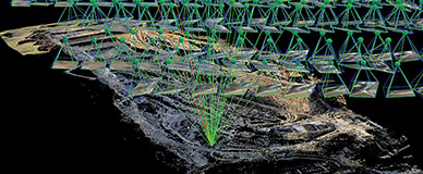

The leading photogrammetry software for professional drone mapping.
Transform your images into survey-grade accurate and georeferenced orthomosaics, points clouds, 2D maps, and 3D models for analysis, inspections, and measurements.
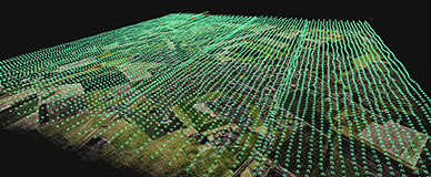

Next-generation photogrammetry software for fast & accurate terrestrial, corridor, and large scale mapping.
Leverage the power of both photogrammetry and terrestrial LiDAR in the same application. Seamlessly export your point cloud into PIX4Dsurvey to create CAD-ready deliverables.


Bridging the gap between photogrammetry and CAD.
Extract data from your point cloud and create CAD-ready deliverables. Merge multiple point clouds in one project, utilizing both LiDAR and photogrammetry data. Use smart automation to create TIN and breakline analysis of complex objects.
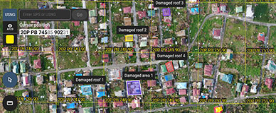

Accurate 2D maps from aerial imagery for reliable situational awareness, processed in minutes.
Mark, measure, and document points of interest on your maps while on the ground and easily share them to provide powerful data for when every second counts.
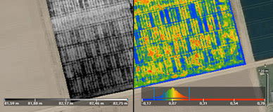

Precision agriculture mapping software for high efficiency and productivity.
Actionable data and insights from drone imagery for crop analysis and digital farming. Create accurate maps in minutes and identify issues using calibrated multispectral or full resolution RGB images. Share your data via PIX4Dcloud or a PDF report.
Try Pix4D software solutions for free
Free 15-day plan. No credit card required.
TRY FOR FREEJoin more than 60'000 Pix4D users around the world who trust us


CUSTOMER SUPPORT
Pix4D is more than just software.


CUSTOMER SUPPORT
Pix4D is more than just software.
| | |
Frequently asked questions
Can I try Pix4D software?
What are my payment options?
Can I purchase just one month?
Can I get trained on the software?
Can I purchase Cloud processing for a PIX4Dmapper licenses?
Can I change or cancel my subscription?
*Limited to specific plans